
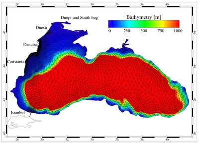
Storm: Kassandra
Kassandra is a storm surge operational forecast system for the Mediterranean and Black seas. It consists in a 3D finite element hydrodynamic model (SHYFEM), including a tidal model, in a third generation finite element spectral wave model (WWMII), fully coupled to the hydrodynamic model and using as meteorological forcing provided by ISAC-CNR.
The Kassandra forecasting system considers several interactions among wave, surge and tide such as the wave contribution to the total water level by means of wave setup, the influence of tide and surge on the water depth, the depth and current refraction of waves by surge water level and currents. The finite element method permitted to follow the details of bathymetry and morphology in the coastal zone, describing the areas of special interest with higher resolution.
The meteorological model chain comprises the global model GFS (resolution of 40 km, six days of forecast), the hydrostatic model BOLAM (resolution of 8.3 km, three days of forecast), covering the Mediterranean and the Black Sea, and the non-hydrostatic model MOLOCH (resolution of 1.25 km, two days of forecast) which covers the Italian peninsula. The numerical simulation system provides daily forecasts, to maximum 4 days each, for the Mediterranean and Black seas at steps of 3 hours for the total water level (tide + surge + wave set-up), surface currents and significant wave height.
Ferrarin C., Roland A., Bajo M., Umgiesser G., Cucco A., Davolio S., Buzzi A., Malguzzi P., Drofa O., 2013. Tide-surge-wave modelling and forecasting in the Mediterranean Sea with focus on the Italian coast. Ocean Modelling, Vol. 61, 38-48, doi: 10.5194/asr-6-227-2011.
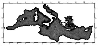
Wind & Waves: Nettuno
Wind and wave forecast up to 72 hours by use of the meteorological model COSMO and the wave model WAM in the Italian seas and in the Mediterranea Sea.
The NETTUNO forecast system was developed in the framework of a collaboration between the Servizio Metereologico Nazionale dell’Aeronatuica Militare (the Italian National Metereological Service of the Italian Military Aviation) and CNR-ISMAR.
The computation of the sea state (i.e. the wave hight) is based on the wind intensity over the sea surface. The fundamental concept at the base of all spectral models is that the sea state is the result of the overlap of waves with different height, length and direction. The spectrum is given by the sum of the energies of each component, defined in frequency and direction. This is generally defined as significant wave height, and is
more or less equivalent to the wave height obtained with a visual observation. CNR-ISMAR, one of the leading institution on wave modeling, participated to the developed of the WAM model (Komen et al. , 1994) and implemented it in collaboration with several national and international research and meteorological institutes. The NETTUNO forecast system is currently operational with an horizontal resolution of 0.05 degrees over the whole Mediterranean Sea providing forecast bulletins every 24 hours.
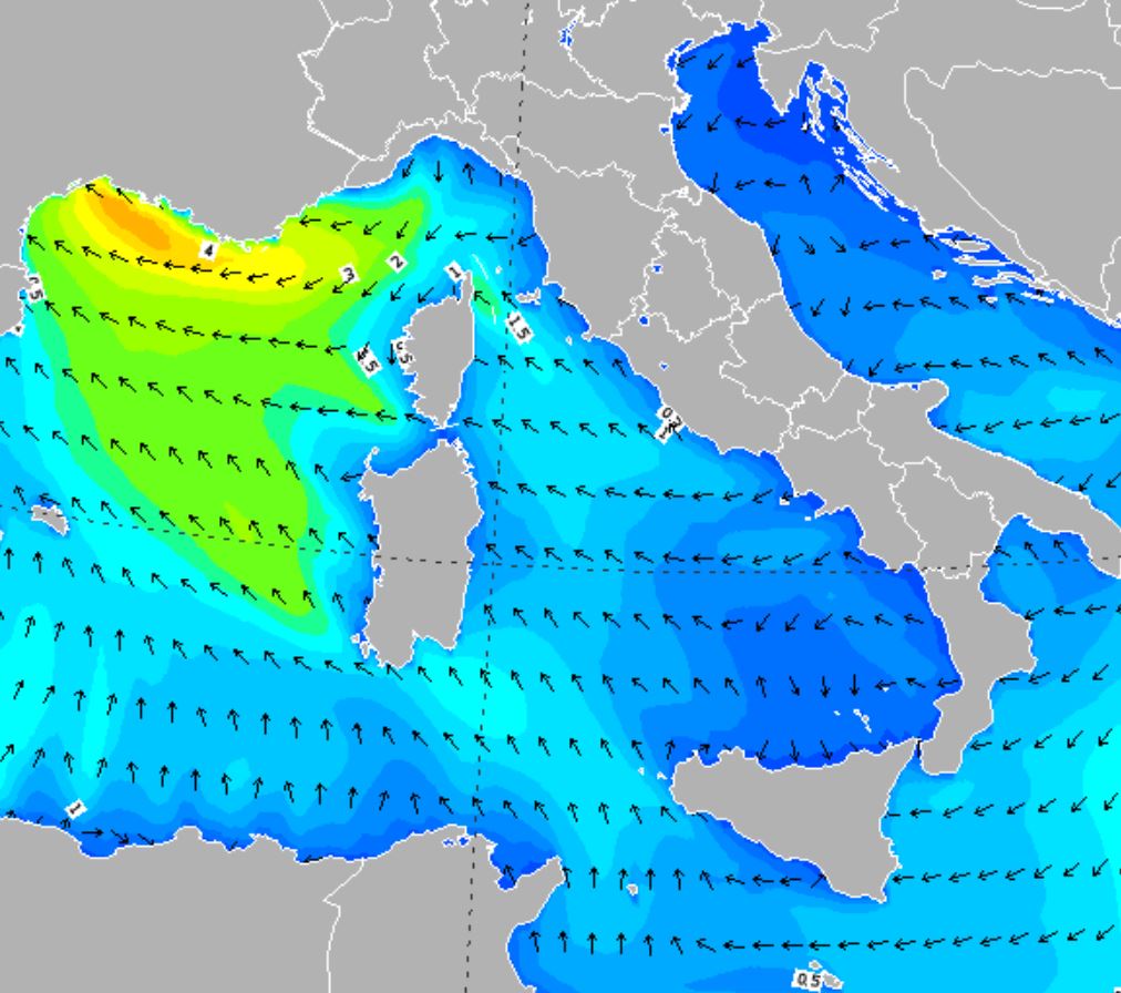
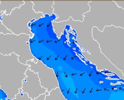
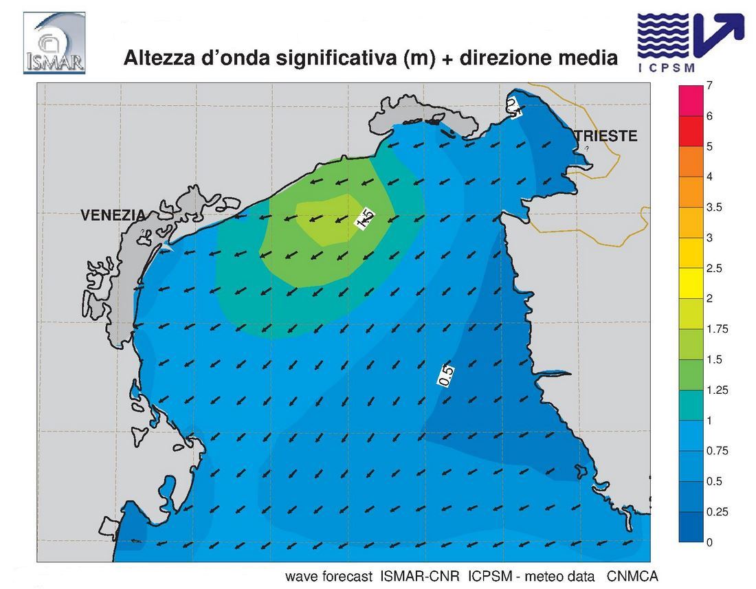
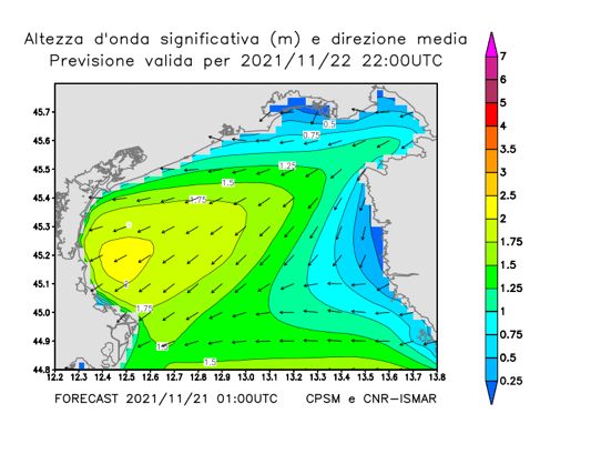
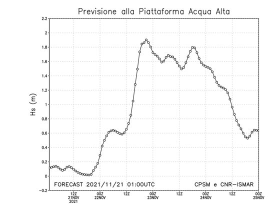
Waves: Henetus
Operational system for forecasting wave motion in the Adriatic Sea based on ECMWF (European Centre for Medium-range Weather Forecasts) forcings in collaboration with the Tide Forecasting and Reporting Center CPSM (Centro Previsione e Segnalazione Maree) of the municipality of Venice
Operational since 1996, the system is continuously upgraded, especially through the correction of the input ECMWF wind fields. These fields are of progressively improved in quality and with the increasing resolution of the meteorological model, the correction needs to be updated correspondingly.
This ensures a practically constant quality of the Henetus results in the Adriatic Sea since 1996. After suitable and extended validation of the quality of the results at different forecast ranges, the operational range has been extended to the present five days. The Henetus results are also used to improve the tidal forecast on the Venetian coasts and the Venice lagoon, particularly during the most severe events.
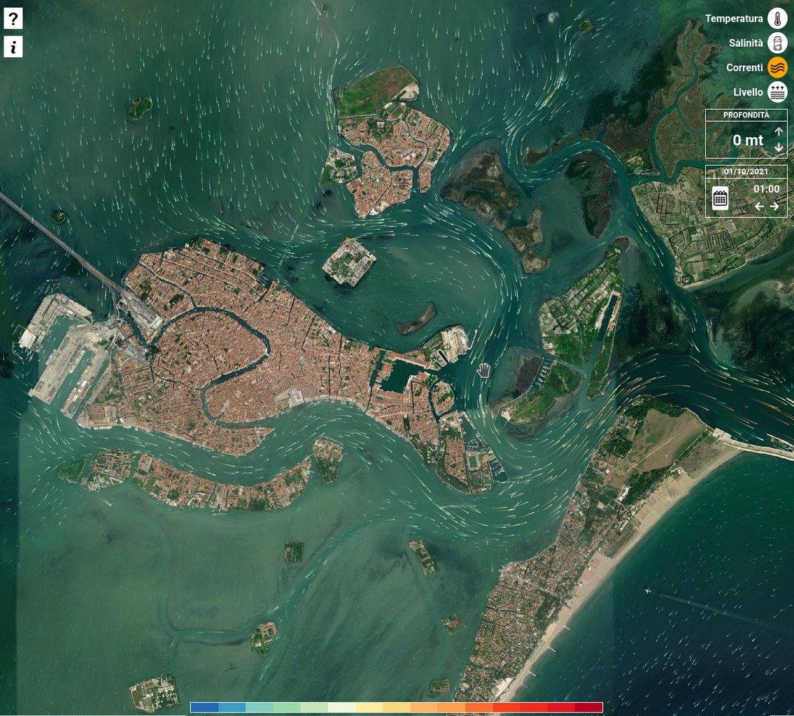
Venice Lagoon: ISSOS
The ISSOS operating system is based on the SHYFEM hydrodynamic model and aims to predict the level, currents, temperature, and salinity in the Venice lagoon for three days. The system performs an initial barotropic simulation in the Mediterranean, calculating the meteorological contribution (storm surge) to the sea level near the Venetian lagoon. Then, from that level, the total level is calculated, taking into account the predicted astronomical tide and the latest observations. A second cascaded simulation, forced with the calculated level and other variables taken from the Copernicus project, as well as the wind and pressure used in the first simulation, makes a barocline prediction in the Venice lagoon. The interface allows you to view currents, salinity and temperature in three dimensions and the level. It is possible to consult three forecast days and the first forecast day of the previous days.
The system was funded as part of the Venezia2021 research project, coordinated by CORILA, with contributions from the Interregional Superintendent of Public Works for Veneto, Trentino Alto Adige and Friuli Venezia Giulia.
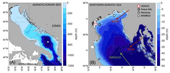
Waves: PELMO
Wave forecast in the Adriatic Sea is regularly carried out by ISMAR using state-of-the-art numerical modeling tools. The PELMO system, in collaboration with the City of Venice, is optimized for forecasting in the Gulf of Venice.
Wave forecasting is of fundamental importance for navigation and management of offshore activities, as well as for assessing the wave effects on shorelines and their morphodynamics. Modern wave forecasting systems are based on numerical wave mode models, forced by weather forecasting model outputs (in particular, wind forecasting).
The quality of the meteorological component is crucial, especially in semi-enclosed seas such as the Adriatic Sea, where the spatio-temporal variability of wind requires high resolution of the data or, alternatively, their correction oriented to the best agreement with observations. In this context, the PELMO (PrevisionE in the Adriatic aLto of Wave Motion) forecasting system, developed in collaboration with the Tide Forecast and Early Warning Center of the City of Venice, has been optimized, through calibration and validation procedures (doi: 10.3389/fmars.2022.1002786), to accurately forecast the waves in the Gulf of Venice. In this particularly meteo-oceanographically complex area, waves play an important role in both coastal evolution and flooding.